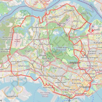
Directions from Duck Tour Ramp to Marina Boulevard, Singapore
- Distance: 105.3 Km
- Elevation gain: 812 m
- Maximum elevation: 51 m
- Elevation loss: 812 m
- Minimum elevation: -4 m
Interactive trail map
Trail profile
- Distance: 105.3 Km
- Elevation gain: 812 m
- Maximum elevation: 51 m
- Elevation loss: 812 m
- Minimum elevation: -4 m
About this trail
Name: Directions from Duck Tour Ramp to Marina Boulevard, Singapore trail, distance, elevation, map, profile, GPS track
Start: Marina Promenade, Tanjong Rhu, Kallang, Central, Singapore, 437435, Singapore (1.29657 103.86389)
End: Marina Promenade, Tanjong Rhu, Kallang, Central, Singapore, 437435, Singapore (1.29657 103.86389)
Coordinates: 1.26559 103.68782 1.46409 103.87231
Other hiking, mountain biking, running and outdoor activity trails
Click on a trail to view its statistics, map and profile.
Bukit Timah Hill - MacRitchie Reservoir
Distance: 14.8 Km • Elevation gain: 290 m • Maximum elevation: 167 m
Singapore Botanical Gardens
Distance: 10.6 Km • Elevation gain: 161 m • Maximum elevation: 40 m
Singapore Botanical Gardens.gpx
Distance: 10.6 Km • Elevation gain: 161 m • Maximum elevation: 40 m
Singapore East Coast Park
Distance: 12.6 Km • Elevation gain: 79 m • Maximum elevation: 22 m
MacRitchie Reservoir and TreeTop Walk Loop
Distance: 12.3 Km • Elevation gain: 207 m • Maximum elevation: 89 m
The Green Corridor - Singapore
Distance: 22.3 Km • Elevation gain: 167 m • Maximum elevation: 44 m
Sungei Buloh Wetland Route
Enjoy the tranquility and serenity of the mangrove habitat is through Route 1. This route goes around the two main ponds and gives a good introduction to the Reserve and the birds of Sungei Buloh, especially during the migratory season from September to March From…
Distance: 2.6 Km • Elevation gain: 16 m • Maximum elevation: 9 m
Tree Top Walk & Bukit Timah Hill in Central Catchment Nature Reserve
Distance: 14.1 Km • Elevation gain: 319 m • Maximum elevation: 166 m
Rail Corridor
Distance: 8.6 Km • Elevation gain: 111 m • Maximum elevation: 53 m
Singapore Botanical Gardens
Distance: 10.6 Km • Elevation gain: 161 m • Maximum elevation: 40 m
Labrador Park
Distance: 8.0 Km • Elevation gain: 91 m • Maximum elevation: 27 m
Marina Parade -> Haji Lane
Distance: 9.4 Km • Elevation gain: 47 m • Maximum elevation: 19 m
Mandai Boardwalk
Distance: 4.4 Km • Elevation gain: 28 m • Maximum elevation: 43 m
Yale NUS walking
Distance: 1.4 Km • Elevation gain: 31 m • Maximum elevation: 25 m