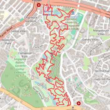
Singapore Botanical Gardens.gpx
- Distance: 10.6 Km
- Elevation gain: 161 m
- Maximum elevation: 40 m
- Elevation loss: 160 m
- Minimum elevation: 4 m
Interactive trail map
Trail profile
- Distance: 10.6 Km
- Elevation gain: 161 m
- Maximum elevation: 40 m
- Elevation loss: 160 m
- Minimum elevation: 4 m
About this trail
Name: Singapore Botanical Gardens.gpx trail, distance, elevation, map, profile, GPS track
Start: Cluny Road, Dalvey Villas, Tanglin, Central, Singapore, 258439, Singapore (1.31522 103.81704)
End: Cluny Road, Dalvey Villas, Tanglin, Central, Singapore, 258439, Singapore (1.31555 103.81687)
Coordinates: 1.30694 103.81332 1.32270 103.81912
Other hiking, mountain biking, running and outdoor activity trails
Click on a trail to view its statistics, map and profile.
Singapore Botanical Gardens
Distance: 10.6 Km • Elevation gain: 161 m • Maximum elevation: 40 m
The Green Corridor - Singapore
Distance: 22.3 Km • Elevation gain: 167 m • Maximum elevation: 44 m
Rail Corridor
Distance: 8.6 Km • Elevation gain: 111 m • Maximum elevation: 53 m
Singapore Botanical Gardens
Distance: 10.6 Km • Elevation gain: 161 m • Maximum elevation: 40 m
Directions from Duck Tour Ramp to Marina Boulevard, Singapore
Distance: 105.3 Km • Elevation gain: 812 m • Maximum elevation: 51 m