Thank you for supporting this site ❤️
Make a donation
Make a donation
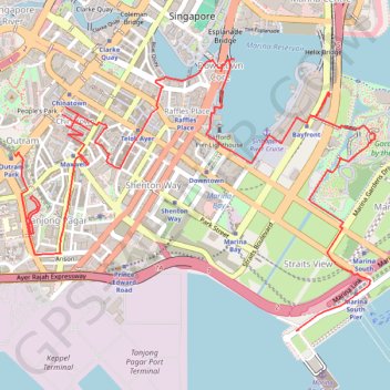
Singapore
https://en-hk.gps-viewer.com/track-181rr/Singapore/
- Distance: 11.8 Km
- Elevation gain: 141 m
- Maximum elevation: 25 m
- Elevation loss: 147 m
- Minimum elevation: -4 m
Interactive trail map
Thank you for supporting this site ❤️
Make a donation
Make a donation
Trail profile
- Distance: 11.8 Km
- Elevation gain: 141 m
- Maximum elevation: 25 m
- Elevation loss: 147 m
- Minimum elevation: -4 m
Thank you for supporting this site ❤️
Make a donation
Make a donation
About this trail
Name: Singapore trail, distance, elevation, map, profile, GPS track
End: Marina Coastal Drive, Straits View, Central, Singapore, 018947, Singapore (1.26908 103.85904)
Coordinates: 1.26899 103.84016 1.28704 103.86409
Thank you for supporting this site ❤️
Make a donation
Make a donation
Other hiking, mountain biking, running and outdoor activity trails
Click on a trail to view its statistics, map and profile.
Singapore East Coast Park
Distance: 12.6 Km • Elevation gain: 79 m • Maximum elevation: 22 m
Thank you for supporting this site ❤️
Make a donation
Make a donation
Directions from Duck Tour Ramp to Marina Boulevard, Singapore
Distance: 105.3 Km • Elevation gain: 812 m • Maximum elevation: 51 m
Thank you for supporting this site ❤️
Make a donation
Make a donation