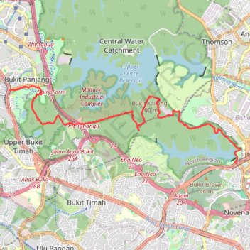
Tree Top Walk & Bukit Timah Hill in Central Catchment Nature Reserve
- Distance: 14.1 Km
- Elevation gain: 319 m
- Maximum elevation: 166 m
- Elevation loss: 305 m
- Minimum elevation: 9 m
- Moving time: 3 h 10 m
- Moving speed: 4.4 Km/h
- Maximum speed: 8.1 Km/h
- Total time: 3 h 23 m
- Global speed: 4.2 Km/h
Interactive trail map
Trail profile
- Distance: 14.1 Km
- Elevation gain: 319 m
- Maximum elevation: 166 m
- Elevation loss: 305 m
- Minimum elevation: 9 m
- Moving time: 3 h 10 m
- Moving speed: 4.4 Km/h
- Maximum speed: 8.1 Km/h
- Total time: 3 h 23 m
- Global speed: 4.2 Km/h
About this trail
Name: Tree Top Walk & Bukit Timah Hill in Central Catchment Nature Reserve trail, distance, elevation, map, profile, GPS track
Start: Lornie Road, Central Water Catchment, North Region, Singapore, 298898, Singapore (1.34162 103.83530)
Coordinates: 1.34154 103.76784 1.36452 103.83652
Other hiking, mountain biking, running and outdoor activity trails
Click on a trail to view its statistics, map and profile.
Bukit Timah Hill - MacRitchie Reservoir
Distance: 14.8 Km • Elevation gain: 290 m • Maximum elevation: 167 m
MacRitchie Reservoir and TreeTop Walk Loop
Distance: 12.3 Km • Elevation gain: 207 m • Maximum elevation: 89 m
The Green Corridor - Singapore
Distance: 22.3 Km • Elevation gain: 167 m • Maximum elevation: 44 m
Directions from Duck Tour Ramp to Marina Boulevard, Singapore
Distance: 105.3 Km • Elevation gain: 812 m • Maximum elevation: 51 m