Chinatown - Singapore
Interactive trail map
Trail profile
- Distance: 4.5 Km
- Elevation gain: 72 m
- Maximum elevation: 23 m
- Elevation loss: 63 m
- Minimum elevation: 1 m
About this trail
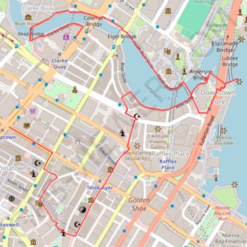
Name: Chinatown - Singapore trail, distance, elevation, map, profile, GPS track
Coordinates: 1.27976 103.84409 1.29024 103.85470
Other hiking, mountain biking, running and outdoor activity trails
Click on a trail to view its statistics, map and profile.
Directions from Duck Tour Ramp to Marina Boulevard, Singapore
Distance: 105.3 Km • Elevation gain: 812 m • Maximum elevation: 51 m