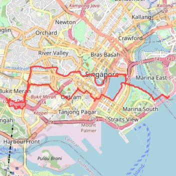
Singapore
- Distance: 21.8 Km
- Elevation gain: 402 m
- Maximum elevation: 53 m
- Elevation loss: 402 m
- Minimum elevation: -4 m
Interactive trail map
Trail profile
- Distance: 21.8 Km
- Elevation gain: 402 m
- Maximum elevation: 53 m
- Elevation loss: 402 m
- Minimum elevation: -4 m
About this trail
Name: Singapore trail, distance, elevation, map, profile, GPS track
Start: 1, Telok Blangah Crescent, Bukit Merah, Central, Singapore, 090011, Singapore (1.27957 103.81796)
End: 1, Telok Blangah Crescent, Bukit Merah, Central, Singapore, 090011, Singapore (1.27954 103.81794)
Coordinates: 1.27687 103.81716 1.29263 103.87634
Other hiking, mountain biking, running and outdoor activity trails
Click on a trail to view its statistics, map and profile.
Singapore East Coast Park
Distance: 12.6 Km • Elevation gain: 79 m • Maximum elevation: 22 m
The Green Corridor - Singapore
Distance: 22.3 Km • Elevation gain: 167 m • Maximum elevation: 44 m
Rail Corridor
Distance: 8.6 Km • Elevation gain: 111 m • Maximum elevation: 53 m
Directions from Duck Tour Ramp to Marina Boulevard, Singapore
Distance: 105.3 Km • Elevation gain: 812 m • Maximum elevation: 51 m