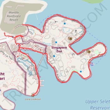
Mandai Boardwalk
- Distance: 4.4 Km
- Elevation gain: 28 m
- Maximum elevation: 43 m
- Elevation loss: 34 m
- Minimum elevation: 27 m
- Moving time: 1 h 10 m
- Moving speed: 3.7 Km/h
- Maximum speed: 11.5 Km/h
- Total time: 1 h 23 m
- Global speed: 3.2 Km/h
Interactive trail map
Trail profile
- Distance: 4.4 Km
- Elevation gain: 28 m
- Maximum elevation: 43 m
- Elevation loss: 34 m
- Minimum elevation: 27 m
- Moving time: 1 h 10 m
- Moving speed: 3.7 Km/h
- Maximum speed: 11.5 Km/h
- Total time: 1 h 23 m
- Global speed: 3.2 Km/h
About this trail
Name: Mandai Boardwalk trail, distance, elevation, map, profile, GPS track
Coordinates: 1.39983 103.78944 1.40662 103.79796
Other hiking, mountain biking, running and outdoor activity trails
Click on a trail to view its statistics, map and profile.
The Green Corridor - Singapore
Distance: 22.3 Km • Elevation gain: 167 m • Maximum elevation: 44 m
Directions from Duck Tour Ramp to Marina Boulevard, Singapore
Distance: 105.3 Km • Elevation gain: 812 m • Maximum elevation: 51 m