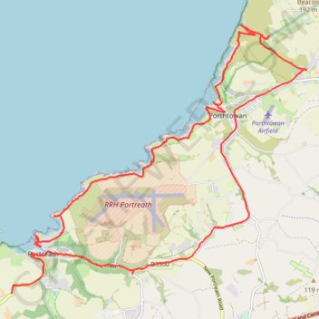
Portreath Oorthtowan Loop
Portreath, Oorthtowan
- Distance: 22.6 Km
- Elevation gain: 852 m
- Maximum elevation: 103 m
- Elevation loss: 782 m
- Minimum elevation: 0 m
- Moving time: 5 h 45 m
- Moving speed: 3.9 Km/h
- Maximum speed: 41.0 Km/h
- Total time: 6 h 59 m
- Global speed: 3.2 Km/h
Interactive trail map
Trail profile
- Distance: 22.6 Km
- Elevation gain: 852 m
- Maximum elevation: 103 m
- Elevation loss: 782 m
- Minimum elevation: 0 m
- Moving time: 5 h 45 m
- Moving speed: 3.9 Km/h
- Maximum speed: 41.0 Km/h
- Total time: 6 h 59 m
- Global speed: 3.2 Km/h
About this trail
Name: Portreath Oorthtowan Loop trail, distance, elevation, map, profile, GPS track
Start: Harbour, Portreath, Cornwall, England, TR16 4LF, United Kingdom (50.26222 -5.29096)
End: B3301, Coombe, Portreath, Cornwall, England, TR14 0BN, United Kingdom (50.25384 -5.29804)
Coordinates: 50.25384 -5.29804 50.30075 -5.21760
Other hiking, mountain biking, running and outdoor activity trails
Click on a trail to view its statistics, map and profile.
St Agnes
United Kingdom > England > Cornwall > St. Agnes
Distance: 11.4 Km • Elevation gain: 571 m • Maximum elevation: 144 m
Godrevy Point - Portreath
United Kingdom > England > Cornwall > Camborne > Gwealavellan
Distance: 21.0 Km • Elevation gain: 938 m • Maximum elevation: 91 m
Bike trip to Bissoe
United Kingdom > England > Cornwall > Redruth
Cycle ride
Distance: 26.7 Km • Elevation gain: 378 m • Maximum elevation: 199 m
Portreath to Porthtowan
United Kingdom > England > Cornwall > Portreath
Distance: 23.7 Km • Elevation gain: 942 m • Maximum elevation: 104 m
Redruth/Illogan Loop
United Kingdom > England > Cornwall > Redruth
Distance: 16.9 Km • Elevation gain: 197 m • Maximum elevation: 137 m
Portreath Walk
United Kingdom > England > Cornwall > Portreath
Distance: 6.6 Km • Elevation gain: 176 m • Maximum elevation: 85 m