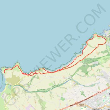
Godrevy Point - Portreath
- Distance: 21.0 Km
- Elevation gain: 938 m
- Maximum elevation: 91 m
- Elevation loss: 933 m
- Minimum elevation: 3 m
Interactive trail map
Trail profile
- Distance: 21.0 Km
- Elevation gain: 938 m
- Maximum elevation: 91 m
- Elevation loss: 933 m
- Minimum elevation: 3 m
About this trail
Name: Godrevy Point - Portreath trail, distance, elevation, map, profile, GPS track
Start: B3301, Gwealavellan, Camborne, Cornwall, England, TR27 5EE, United Kingdom (50.23592 -5.36697)
End: B3301, Coombe, Camborne, Cornwall, England, TR14 0BN, United Kingdom (50.23557 -5.36650)
Coordinates: 50.23552 -5.39265 50.26176 -5.29000
Other hiking, mountain biking, running and outdoor activity trails
Click on a trail to view its statistics, map and profile.
Portreath Oorthtowan Loop
United Kingdom > England > Cornwall > Portreath
Portreath, Oorthtowan
Distance: 22.6 Km • Elevation gain: 852 m • Maximum elevation: 103 m
Hayle to Godrevy Point
United Kingdom > England > Cornwall > Hayle > Phillack
Distance: 21.8 Km • Elevation gain: 376 m • Maximum elevation: 61 m
Portreath to Porthtowan
United Kingdom > England > Cornwall > Portreath
Distance: 23.7 Km • Elevation gain: 942 m • Maximum elevation: 104 m
Redruth/Illogan Loop
United Kingdom > England > Cornwall > Redruth
Distance: 16.9 Km • Elevation gain: 197 m • Maximum elevation: 137 m
Portreath Walk
United Kingdom > England > Cornwall > Portreath
Distance: 6.6 Km • Elevation gain: 176 m • Maximum elevation: 85 m