Bike trip to Bissoe
Cycle ride
- Distance: 26.7 Km
- Elevation gain: 378 m
- Maximum elevation: 199 m
- Elevation loss: 378 m
- Minimum elevation: 13 m
- Moving time: 1 h 48 m
- Moving speed: 14.8 Km/h
- Maximum speed: 49.8 Km/h
- Total time: 1 h 58 m
- Global speed: 13.5 Km/h
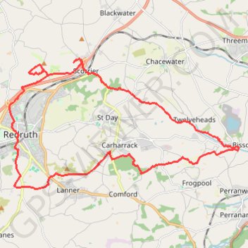
Interactive trail map
Trail profile
- Distance: 26.7 Km
- Elevation gain: 378 m
- Maximum elevation: 199 m
- Elevation loss: 378 m
- Minimum elevation: 13 m
- Moving time: 1 h 48 m
- Moving speed: 14.8 Km/h
- Maximum speed: 49.8 Km/h
- Total time: 1 h 58 m
- Global speed: 13.5 Km/h
About this trail
Name: Bike trip to Bissoe trail, distance, elevation, map, profile, GPS track
Start: Gilly Fields, Redruth, Cornwall, England, TR15 2SZ, United Kingdom (50.22886 -5.22826)
End: 1, Gilly Fields, Redruth, Cornwall, England, TR15 2TB, United Kingdom (50.22888 -5.22820)
Coordinates: 50.21667 -5.23288 50.25754 -5.12010
Other hiking, mountain biking, running and outdoor activity trails
Click on a trail to view its statistics, map and profile.
Poldice Valley and Carn Marth loop
United Kingdom > England > Cornwall > Falmouth
Distance: 38.6 Km • Elevation gain: 700 m • Maximum elevation: 227 m
Portreath Oorthtowan Loop
United Kingdom > England > Cornwall > Portreath
Portreath, Oorthtowan
Distance: 22.6 Km • Elevation gain: 852 m • Maximum elevation: 103 m
Portreath to Porthtowan
United Kingdom > England > Cornwall > Portreath
Distance: 23.7 Km • Elevation gain: 942 m • Maximum elevation: 104 m
Redruth/Illogan Loop
United Kingdom > England > Cornwall > Redruth
Distance: 16.9 Km • Elevation gain: 197 m • Maximum elevation: 137 m