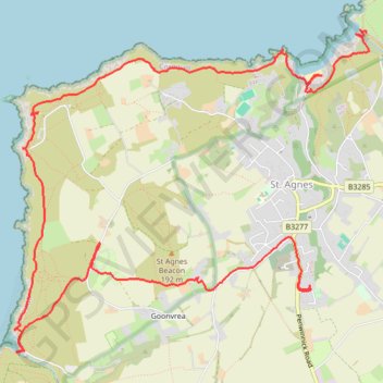
St Agnes
- Distance: 11.4 Km
- Elevation gain: 571 m
- Maximum elevation: 144 m
- Elevation loss: 480 m
- Minimum elevation: 1 m
- Moving time: 3 h 28 m
- Moving speed: 3.3 Km/h
- Maximum speed: 11.7 Km/h
- Total time: 4 h 32 m
- Global speed: 2.5 Km/h
Interactive trail map
Trail profile
- Distance: 11.4 Km
- Elevation gain: 571 m
- Maximum elevation: 144 m
- Elevation loss: 480 m
- Minimum elevation: 1 m
- Moving time: 3 h 28 m
- Moving speed: 3.3 Km/h
- Maximum speed: 11.7 Km/h
- Total time: 4 h 32 m
- Global speed: 2.5 Km/h
About this trail
Name: St Agnes trail, distance, elevation, map, profile, GPS track
End: Penwinnick Road, St. Agnes, Cornwall, England, TR5 0LA, United Kingdom (50.30576 -5.20278)
Coordinates: 50.30002 -5.23512 50.32343 -5.19500
Other hiking, mountain biking, running and outdoor activity trails
Click on a trail to view its statistics, map and profile.
St Agnes Beacon & Wheal Coates
United Kingdom > England > Cornwall > St. Agnes > Goonvrea
Distance: 3.8 Km • Elevation gain: 52 m • Maximum elevation: 106 m
Portreath Oorthtowan Loop
United Kingdom > England > Cornwall > Portreath
Portreath, Oorthtowan
Distance: 22.6 Km • Elevation gain: 852 m • Maximum elevation: 103 m
Around Perranporth
United Kingdom > England > Cornwall > Perranzabuloe
Distance: 23.1 Km • Elevation gain: 867 m • Maximum elevation: 102 m
Portreath to Porthtowan
United Kingdom > England > Cornwall > Portreath
Distance: 23.7 Km • Elevation gain: 942 m • Maximum elevation: 104 m
Perranporth
United Kingdom > England > Cornwall > Goonhavern > Rosehill
Distance: 14.2 Km • Elevation gain: 569 m • Maximum elevation: 97 m