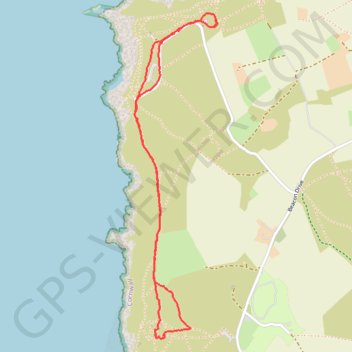
St Agnes Beacon & Wheal Coates
- Distance: 3.8 Km
- Elevation gain: 52 m
- Maximum elevation: 106 m
- Elevation loss: 52 m
- Minimum elevation: 88 m
Interactive trail map
Trail profile
- Distance: 3.8 Km
- Elevation gain: 52 m
- Maximum elevation: 106 m
- Elevation loss: 52 m
- Minimum elevation: 88 m
About this trail
Name: St Agnes Beacon & Wheal Coates trail, distance, elevation, map, profile, GPS track
Start: Beacon Drive, Goonvrea, St. Agnes, Cornwall, England, TR5 0NU, United Kingdom (50.31800 -5.22814)
End: Beacon Drive, Goonvrea, St. Agnes, Cornwall, England, TR5 0NU, United Kingdom (50.31802 -5.22818)
Coordinates: 50.30522 -5.23332 50.31833 -5.22814
Other hiking, mountain biking, running and outdoor activity trails
Click on a trail to view its statistics, map and profile.
St Agnes
United Kingdom > England > Cornwall > St. Agnes
Distance: 11.4 Km • Elevation gain: 571 m • Maximum elevation: 144 m