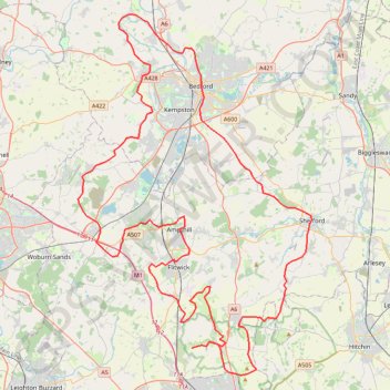
Route
- Distance: 113.0 Km
- Elevation gain: 903 m
- Maximum elevation: 170 m
- Elevation loss: 903 m
- Minimum elevation: 28 m
Interactive trail map
Trail profile
- Distance: 113.0 Km
- Elevation gain: 903 m
- Maximum elevation: 170 m
- Elevation loss: 903 m
- Minimum elevation: 28 m
About this trail
Name: Route trail, distance, elevation, map, profile, GPS track
Coordinates: 51.92538 -0.61265 52.18811 -0.33532
Other hiking, mountain biking, running and outdoor activity trails
Click on a trail to view its statistics, map and profile.
The Jo Cox Way 2022 Day 4 - Milton Keynes to Uxbridge
United Kingdom > England > City of Milton Keynes > Milton Keynes > Monkston
Distance: 104.4 Km • Elevation gain: 1,038 m • Maximum elevation: 251 m
The Jo Cox Way 2022 Day 3 Market Bosworth to Milton Keynes
United Kingdom > England > Leicestershire > Hinckley and Bosworth > Market Bosworth
Distance: 122.9 Km • Elevation gain: 953 m • Maximum elevation: 195 m
The JCW 23 - Cranfield to Uxbridge
United Kingdom > England > Central Bedfordshire > Cranfield
Distance: 90.1 Km • Elevation gain: 863 m • Maximum elevation: 266 m
Deacon Hill
United Kingdom > England > Hertfordshire > North Hertfordshire
Letchworth, Ickleford, Pirton, Deacon Hill and return
Distance: 26.5 Km • Elevation gain: 293 m • Maximum elevation: 182 m
North Chilterns 50k 2022
United Kingdom > England > Hertfordshire > North Hertfordshire > Offley > Mangrove Green
Distance: 49.9 Km • Elevation gain: 765 m • Maximum elevation: 192 m
JCW25 Day 4
United Kingdom > England > Central Bedfordshire > Cranfield
Distance: 105.9 Km • Elevation gain: 965 m • Maximum elevation: 266 m
Flitwick
United Kingdom > England > Central Bedfordshire > Flitwick
Distance: 16.6 Km • Elevation gain: 142 m • Maximum elevation: 111 m