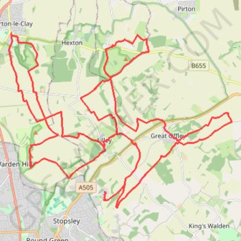
North Chilterns 50k 2022
- Distance: 49.9 Km
- Elevation gain: 765 m
- Maximum elevation: 192 m
- Elevation loss: 760 m
- Minimum elevation: 71 m
Interactive trail map
Trail profile
- Distance: 49.9 Km
- Elevation gain: 765 m
- Maximum elevation: 192 m
- Elevation loss: 760 m
- Minimum elevation: 71 m
About this trail
Name: North Chilterns 50k 2022 trail, distance, elevation, map, profile, GPS track
Coordinates: 51.90476 -0.42715 51.96389 -0.30419
Other hiking, mountain biking, running and outdoor activity trails
Click on a trail to view its statistics, map and profile.
Hitchin Outer Orbital Path (HOOP)
United Kingdom > England > Hertfordshire > North Hertfordshire > Hitchin
Distance: 19.1 Km • Elevation gain: 176 m • Maximum elevation: 100 m
Deacon Hill
United Kingdom > England > Hertfordshire > North Hertfordshire
Letchworth, Ickleford, Pirton, Deacon Hill and return
Distance: 26.5 Km • Elevation gain: 293 m • Maximum elevation: 182 m
Route
United Kingdom > England > Central Bedfordshire > Upper Sundon
Distance: 113.0 Km • Elevation gain: 903 m • Maximum elevation: 170 m