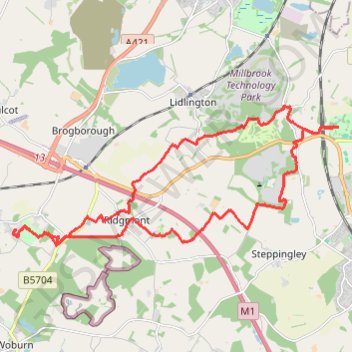
Crawley Park to Ampthill Park Loop
Loop hike from Crawley Park to Ampthill Park. #Hiking #Loop #Countryside #Nature #Forest #Park
- Distance: 24.1 Km
- Elevation gain: 259 m
- Maximum elevation: 133 m
- Elevation loss: 259 m
- Minimum elevation: 73 m
- Moving time: 4 h 21 m
- Moving speed: 5.5 Km/h
- Maximum speed: 9.7 Km/h
- Total time: 4 h 37 m
- Global speed: 5.2 Km/h
Interactive trail map
Trail profile
- Distance: 24.1 Km
- Elevation gain: 259 m
- Maximum elevation: 133 m
- Elevation loss: 259 m
- Minimum elevation: 73 m
- Moving time: 4 h 21 m
- Moving speed: 5.5 Km/h
- Maximum speed: 9.7 Km/h
- Total time: 4 h 37 m
- Global speed: 5.2 Km/h
About this trail
Name: Crawley Park to Ampthill Park Loop trail, distance, elevation, map, profile, GPS track
Coordinates: 52.00954 -0.61993 52.03924 -0.50795
Other hiking, mountain biking, running and outdoor activity trails
Click on a trail to view its statistics, map and profile.
The Jo Cox Way 2022 Day 4 - Milton Keynes to Uxbridge
United Kingdom > England > City of Milton Keynes > Milton Keynes > Monkston
Distance: 104.4 Km • Elevation gain: 1,038 m • Maximum elevation: 251 m
The Jo Cox Way 2022 Day 3 Market Bosworth to Milton Keynes
United Kingdom > England > Leicestershire > Hinckley and Bosworth > Market Bosworth
Distance: 122.9 Km • Elevation gain: 953 m • Maximum elevation: 195 m
The JCW 23 - Cranfield to Uxbridge
United Kingdom > England > Central Bedfordshire > Cranfield
Distance: 90.1 Km • Elevation gain: 863 m • Maximum elevation: 266 m
JCW25 Day 4
United Kingdom > England > Central Bedfordshire > Cranfield
Distance: 105.9 Km • Elevation gain: 965 m • Maximum elevation: 266 m
Route
United Kingdom > England > Central Bedfordshire > Upper Sundon
Distance: 113.0 Km • Elevation gain: 903 m • Maximum elevation: 170 m