Make a donation
Tracked with OSMTracker for Android™
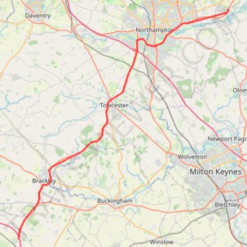
Brackley to Northampton
- Distance: 56.5 Km
- Elevation gain: 404 m
- Maximum elevation: 147 m
- Elevation loss: 444 m
- Minimum elevation: 56 m
Interactive trail map
Make a donation
Trail profile
- Distance: 56.5 Km
- Elevation gain: 404 m
- Maximum elevation: 147 m
- Elevation loss: 444 m
- Minimum elevation: 56 m
Make a donation
About this trail
Name: Tracked with OSMTracker for Android™ trail, distance, elevation, map, profile, GPS track
Coordinates: 51.94805 -1.20583 52.26623 -0.72954
Make a donation
Other hiking, mountain biking, running and outdoor activity trails
Click on a trail to view its statistics, map and profile.
The Jo Cox Way 2022 Day 3 Market Bosworth to Milton Keynes
United Kingdom > England > Leicestershire > Hinckley and Bosworth > Market Bosworth
Distance: 122.9 Km • Elevation gain: 953 m • Maximum elevation: 195 m
The Jo Cox Way 2022 Day 4 - Milton Keynes to Uxbridge
United Kingdom > England > City of Milton Keynes > Milton Keynes > Monkston
Distance: 104.4 Km • Elevation gain: 1,038 m • Maximum elevation: 251 m
The JCW 23 - Cranfield to Uxbridge
United Kingdom > England > Central Bedfordshire > Cranfield
Distance: 90.1 Km • Elevation gain: 863 m • Maximum elevation: 266 m
Parks and Ride Stony
United Kingdom > England > City of Milton Keynes > Milton Keynes > Wolverton
Milton Keynes Cycling
Distance: 9.9 Km • Elevation gain: 51 m • Maximum elevation: 90 m
Make a donation
Tracked with OSMTracker for Android™
United Kingdom > England > West Northamptonshire > Whitfield
Brackley to Oxford
Distance: 51.2 Km • Elevation gain: 225 m • Maximum elevation: 137 m