Thank you for supporting this site ❤️
Make a donation
Make a donation
Tracked with OSMTracker for Android™
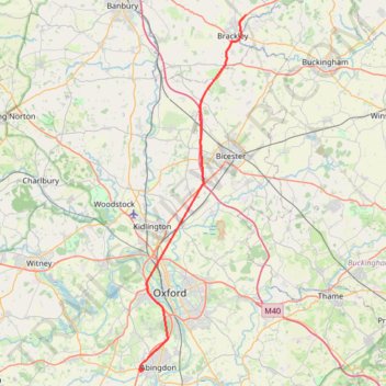
Brackley to Oxford
- Distance: 51.2 Km
- Elevation gain: 225 m
- Maximum elevation: 137 m
- Elevation loss: 302 m
- Minimum elevation: 52 m
Interactive trail map
Thank you for supporting this site ❤️
Make a donation
Make a donation
Trail profile
- Distance: 51.2 Km
- Elevation gain: 225 m
- Maximum elevation: 137 m
- Elevation loss: 302 m
- Minimum elevation: 52 m
Thank you for supporting this site ❤️
Make a donation
Make a donation
About this trail
Name: Tracked with OSMTracker for Android™ trail, distance, elevation, map, profile, GPS track
Start: A43, Whitfield, West Northamptonshire, England, NN13 5GJ, United Kingdom (52.05036 -1.12410)
Coordinates: 51.66688 -1.30979 52.05045 -1.12410
Thank you for supporting this site ❤️
Make a donation
Make a donation
Other hiking, mountain biking, running and outdoor activity trails
Click on a trail to view its statistics, map and profile.
The Jo Cox Way 2022 Day 3 Market Bosworth to Milton Keynes
United Kingdom > England > Leicestershire > Hinckley and Bosworth > Market Bosworth
Distance: 122.9 Km • Elevation gain: 953 m • Maximum elevation: 195 m
Dean2023-311
United Kingdom > England > Oxfordshire > Oxford
Distance: 310.3 Km • Elevation gain: 3,366 m • Maximum elevation: 290 m
Tracked with OSMTracker for Android™
United Kingdom > England > Oxfordshire > Cherwell District > Fewcott
Brackley to Northampton
Distance: 56.5 Km • Elevation gain: 404 m • Maximum elevation: 147 m