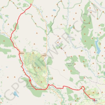
Alyth to Spittal of Glenshee - Cateran Trail (some of)
- Distance: 44.2 Km
- Elevation gain: 1,134 m
- Maximum elevation: 650 m
- Elevation loss: 899 m
- Minimum elevation: 99 m
- Moving time: 4 h 3 m
- Moving speed: 10.9 Km/h
- Maximum speed: 43.2 Km/h
- Total time: 4 h 41 m
- Global speed: 9.4 Km/h
Interactive trail map
Trail profile
- Distance: 44.2 Km
- Elevation gain: 1,134 m
- Maximum elevation: 650 m
- Elevation loss: 899 m
- Minimum elevation: 99 m
- Moving time: 4 h 3 m
- Moving speed: 10.9 Km/h
- Maximum speed: 43.2 Km/h
- Total time: 4 h 41 m
- Global speed: 9.4 Km/h
About this trail
Name: Alyth to Spittal of Glenshee - Cateran Trail (some of) trail, distance, elevation, map, profile, GPS track
Start: Alexandra Street, Alyth, Perth and Kinross, Scotland, PH11 8AU, United Kingdom (56.62128 -3.23327)
End: Spittal of Glenshee, Perth and Kinross, Scotland, PH10 7QE, United Kingdom (56.81373 -3.46002)
Coordinates: 56.62128 -3.53599 56.81403 -3.23014
Other hiking, mountain biking, running and outdoor activity trails
Click on a trail to view its statistics, map and profile.
Loop Gravel Ride around Blairgowrie and Rattray between Loch of Clunie and Alyth
United Kingdom > Scotland > Perth and Kinross > Newlands
Distance: 39.7 Km • Elevation gain: 529 m • Maximum elevation: 281 m
Around Kirton of Glenisla, Angus, UK
United Kingdom > Scotland > Angus > Kirkton of Glenisla
Planned eMTB Gravel: Kirkton of Glenisla - 3-hills Loop UK, Angus, Kirkton of Glenisla
Distance: 21.2 Km • Elevation gain: 485 m • Maximum elevation: 432 m
Spittal of Glenshee to Alyth - Some of the Cateran Trail
United Kingdom > Scotland > Perth and Kinross > Spittal of Glenshee
Distance: 38.3 Km • Elevation gain: 561 m • Maximum elevation: 459 m
EMTB Gravel: Auchintaple Loch Loop
United Kingdom > Scotland > Angus > Folda > Little Forter
Around Auchintaple Loch, nr Folda, Angus
Distance: 15.7 Km • Elevation gain: 394 m • Maximum elevation: 457 m
Cycle to Loch à Chait, Craigsheal and Buckinhill
United Kingdom > Scotland > Perth and Kinross > Butterstone
Distance: 12.9 Km • Elevation gain: 308 m • Maximum elevation: 430 m
Around Kirkmichael, Perthshire
United Kingdom > Scotland > Perth and Kinross > Kirkmichael
Distance: 7.8 Km • Elevation gain: 88 m • Maximum elevation: 274 m
Enochdhu to Upper Lunch Hut Loop
United Kingdom > Scotland > Perth and Kinross > Enochdhu
Mountain Bike Ride
Distance: 10.9 Km • Elevation gain: 263 m • Maximum elevation: 480 m
Around Loch Ordie
United Kingdom > Scotland > Perth and Kinross
Mountain Bike Ride, UK, Perthshire, Dunkeld
Distance: 35.8 Km • Elevation gain: 579 m • Maximum elevation: 300 m
Around Bridge of Cally
United Kingdom > Scotland > Perth and Kinross > Bridge of Cally > Netherton
Distance: 13.3 Km • Elevation gain: 282 m • Maximum elevation: 293 m