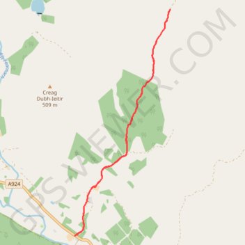
Enochdhu to Upper Lunch Hut Loop
Mountain Bike Ride
- Distance: 10.9 Km
- Elevation gain: 263 m
- Maximum elevation: 480 m
- Elevation loss: 263 m
- Minimum elevation: 255 m
- Moving time: 1 h 8 m
- Moving speed: 9.5 Km/h
- Maximum speed: 19.4 Km/h
- Total time: 1 h 19 m
- Global speed: 8.2 Km/h
Interactive trail map
Trail profile
- Distance: 10.9 Km
- Elevation gain: 263 m
- Maximum elevation: 480 m
- Elevation loss: 263 m
- Minimum elevation: 255 m
- Moving time: 1 h 8 m
- Moving speed: 9.5 Km/h
- Maximum speed: 19.4 Km/h
- Total time: 1 h 19 m
- Global speed: 8.2 Km/h
About this trail
Name: Enochdhu to Upper Lunch Hut Loop trail, distance, elevation, map, profile, GPS track
Start: A924, Enochdhu, Perth and Kinross, Scotland, PH10 7PE, United Kingdom (56.74747 -3.53500)
End: A924, Enochdhu, Perth and Kinross, Scotland, PH10 7PE, United Kingdom (56.74738 -3.53484)
Coordinates: 56.74738 -3.53500 56.78847 -3.50338
Other hiking, mountain biking, running and outdoor activity trails
Click on a trail to view its statistics, map and profile.
Alyth to Spittal of Glenshee - Cateran Trail (some of)
United Kingdom > Scotland > Perth and Kinross > Alyth
Distance: 44.2 Km • Elevation gain: 1,134 m • Maximum elevation: 650 m
Around Kirkmichael, Perthshire
United Kingdom > Scotland > Perth and Kinross > Kirkmichael
Distance: 7.8 Km • Elevation gain: 88 m • Maximum elevation: 274 m