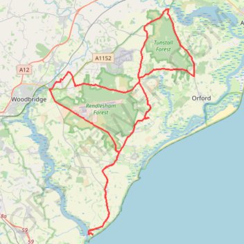
Tunstall Forest and Rendlesham Forest Loop from Bawdsey Manor
- Distance: 65.2 Km
- Elevation gain: 403 m
- Maximum elevation: 34 m
- Elevation loss: 403 m
- Minimum elevation: -1 m
- Moving time: 2 h 35 m
- Moving speed: 25.2 Km/h
- Maximum speed: 40.9 Km/h
- Total time: 2 h 57 m
- Global speed: 22.1 Km/h
Interactive trail map
Trail profile
- Distance: 65.2 Km
- Elevation gain: 403 m
- Maximum elevation: 34 m
- Elevation loss: 403 m
- Minimum elevation: -1 m
- Moving time: 2 h 35 m
- Moving speed: 25.2 Km/h
- Maximum speed: 40.9 Km/h
- Total time: 2 h 57 m
- Global speed: 22.1 Km/h
About this trail
Name: Tunstall Forest and Rendlesham Forest Loop from Bawdsey Manor trail, distance, elevation, map, profile, GPS track
Coordinates: 51.99001 1.34612 52.16264 1.52613
Other hiking, mountain biking, running and outdoor activity trails
Click on a trail to view its statistics, map and profile.
Shottisham - Aldertom - Shingle Street - Hollesley - Shottisham
United Kingdom > England > Suffolk > East Suffolk > Shottisham
Distance: 18.2 Km • Elevation gain: 92 m • Maximum elevation: 24 m
Suffolk Coastal Trail Running
United Kingdom > England > Suffolk > East Suffolk > Hollesley
Woodbridge
Distance: 22.0 Km • Elevation gain: 118 m • Maximum elevation: 28 m
Dunwich to Aldborough loop ride
United Kingdom > England > Suffolk > East Suffolk > Dunwich
Distance: 58.2 Km • Elevation gain: 352 m • Maximum elevation: 41 m
Walk to Saxmundham
United Kingdom > England > Suffolk > East Suffolk > Campsea Ashe
Distance: 17.8 Km • Elevation gain: 96 m • Maximum elevation: 30 m