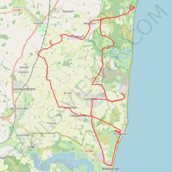
Dunwich to Aldborough loop ride
- Distance: 58.2 Km
- Elevation gain: 352 m
- Maximum elevation: 41 m
- Elevation loss: 352 m
- Minimum elevation: 1 m
- Moving time: 3 h 25 m
- Moving speed: 17.0 Km/h
- Maximum speed: 41.7 Km/h
- Total time: 5 h 39 m
- Global speed: 10.3 Km/h
Interactive trail map
Trail profile
- Distance: 58.2 Km
- Elevation gain: 352 m
- Maximum elevation: 41 m
- Elevation loss: 352 m
- Minimum elevation: 1 m
- Moving time: 3 h 25 m
- Moving speed: 17.0 Km/h
- Maximum speed: 41.7 Km/h
- Total time: 5 h 39 m
- Global speed: 10.3 Km/h
About this trail
Name: Dunwich to Aldborough loop ride trail, distance, elevation, map, profile, GPS track
Coordinates: 52.15462 1.50921 52.27810 1.63191
Other hiking, mountain biking, running and outdoor activity trails
Click on a trail to view its statistics, map and profile.
Suffolk Coast Path - Dunwich to Walberwick Loop
United Kingdom > England > Suffolk > East Suffolk > Dunwich
Distance: 22.4 Km • Elevation gain: 125 m • Maximum elevation: 22 m
Tunstall Forest and Rendlesham Forest Loop from Bawdsey Manor
United Kingdom > England > Suffolk > East Suffolk > Bawdsey
Distance: 65.2 Km • Elevation gain: 403 m • Maximum elevation: 34 m
Various tracks in Dunwich forest
United Kingdom > England > Suffolk > East Suffolk > Westleton
Distance: 16.1 Km • Elevation gain: 107 m • Maximum elevation: 23 m