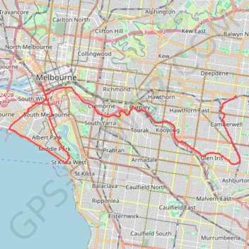
Canterbury - Gardiners Creek - Melbourne
Interactive trail map
Trail profile
- Distance: 32.9 Km
- Elevation gain: 255 m
- Maximum elevation: 66 m
- Elevation loss: 304 m
- Minimum elevation: 0 m
About this trail
Name: Canterbury - Gardiners Creek - Melbourne trail, distance, elevation, map, profile, GPS track
Coordinates: -37.85930 144.93265 -37.81813 145.08301
Other hiking, mountain biking, running and outdoor activity trails
Click on a trail to view its statistics, map and profile.
Running around Albert Park Lake
Australia > Victoria > Melbourne
Distance: 13.0 Km • Elevation gain: 73 m • Maximum elevation: 20 m
Jolimont Station to Ashburton along Yarra River, Gardiners Creek and Ferndale Trails
Australia > Victoria > Melbourne
Distance: 14.4 Km • Elevation gain: 115 m • Maximum elevation: 56 m
Fawkner Park and Royal Botanic Gardens loop walk
Australia > Victoria > Melbourne
Distance: 12.0 Km • Elevation gain: 137 m • Maximum elevation: 38 m
Ashburton to Mernda (cycle)
Australia > Victoria > Melbourne
Distance: 42.2 Km • Elevation gain: 392 m • Maximum elevation: 163 m
Zeopoxa Cycling
Australia > Victoria > Melbourne
Distance: 11.2 Km • Elevation gain: 95 m • Maximum elevation: 31 m