Blood Mountain via Byron Reece Trail and Appalachian Trail in Blood Mountain Wilderness
The hike to Blood Mountain offers a fantastic immersion into the serene beauty of North Georgia's mountainous landscape. Along the route, hikers are treated to dense, moss-filled forests, rocky outcrops, and breathtaking panoramic views from the summit, where one can gaze out over the Blue Ridge Mountains. The journey culminates at the historic Blood Mountain Shelter, perched on the mountaintop, with stunning vistas to the south and west, making it a rewarding challenge for those seeking both natural beauty and a sense of accomplishment. #Hiking #Mountain #Overlook #Forest #Nature
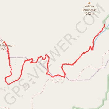
- Distance: 6.7 Km
- Elevation gain: 429 m
- Maximum elevation: 1,338 m
- Elevation loss: 427 m
- Minimum elevation: 924 m
- Moving time: 2 h 34 m
- Moving speed: 2.6 Km/h
- Maximum speed: 5.3 Km/h
- Total time: 3 h 43 m
- Global speed: 1.8 Km/h
Interactive trail map
Trail profile
- Distance: 6.7 Km
- Elevation gain: 429 m
- Maximum elevation: 1,338 m
- Elevation loss: 427 m
- Minimum elevation: 924 m
- Moving time: 2 h 34 m
- Moving speed: 2.6 Km/h
- Maximum speed: 5.3 Km/h
- Total time: 3 h 43 m
- Global speed: 1.8 Km/h
About this trail
Name: Blood Mountain via Byron Reece Trail and Appalachian Trail in Blood Mountain Wilderness trail, distance, elevation, map, profile, GPS track
End: Byron Herbert Reece, Union County, Georgia, United States (34.74150 -83.92269)
Coordinates: 34.73477 -83.93696 34.74173 -83.92269
Other hiking, mountain biking, running and outdoor activity trails
Click on a trail to view its statistics, map and profile.
Blood Mountain via Byron Herbert Reece and Appalachian Trail
United States > Georgia > Union County
The hike to Blood Mountain via the Byron Herbert Reece Trail and Appalachian Trail offers a dynamic journey through lush forest canopies, rocky outcrops, and sweeping summit views. The route begins with a steady ascent through a valley lined with rhododendrons, ferns, and moss-covered boulders, eventually…
Distance: 6.9 Km • Elevation gain: 430 m • Maximum elevation: 1,338 m