Blood Mountain via Byron Herbert Reece and Appalachian Trail
The hike to Blood Mountain via the Byron Herbert Reece Trail and Appalachian Trail offers a dynamic journey through lush forest canopies, rocky outcrops, and sweeping summit views. The route begins with a steady ascent through a valley lined with rhododendrons, ferns, and moss-covered boulders, eventually connecting with the Appalachian Trail at Flatrock Gap. As hikers climb, they encounter striking stone staircases, grooved rock clearings, and lichen-covered boulders, all leading to a breathtaking summit with panoramic views of the surrounding southern Blue Ridge Mountains, the rolling Appalachian Mountains and the vast hardwood forests below. #Hiking #Mountain #Forest #Nature #Overlook
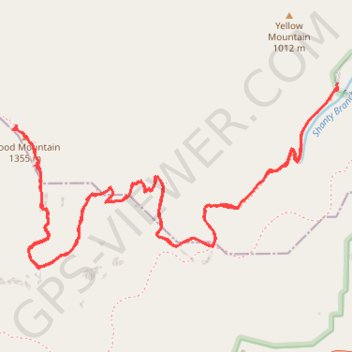
- Distance: 6.9 Km
- Elevation gain: 430 m
- Maximum elevation: 1,338 m
- Elevation loss: 429 m
- Minimum elevation: 925 m
- Moving time: 1 h 50 m
- Moving speed: 3.8 Km/h
- Maximum speed: 12.2 Km/h
- Total time: 2 h 38 m
- Global speed: 2.6 Km/h
Interactive trail map
Trail profile
- Distance: 6.9 Km
- Elevation gain: 430 m
- Maximum elevation: 1,338 m
- Elevation loss: 429 m
- Minimum elevation: 925 m
- Moving time: 1 h 50 m
- Moving speed: 3.8 Km/h
- Maximum speed: 12.2 Km/h
- Total time: 2 h 38 m
- Global speed: 2.6 Km/h
About this trail
Name: Blood Mountain via Byron Herbert Reece and Appalachian Trail trail, distance, elevation, map, profile, GPS track
End: Byron Herbert Reece, Union County, Georgia, United States (34.74157 -83.92271)
Coordinates: 34.73475 -83.93754 34.74172 -83.92263
Other hiking, mountain biking, running and outdoor activity trails
Click on a trail to view its statistics, map and profile.
Blood Mountain via Byron Reece Trail and Appalachian Trail in Blood Mountain Wilderness
United States > Georgia > Union County
The hike to Blood Mountain offers a fantastic immersion into the serene beauty of North Georgia's mountainous landscape. Along the route, hikers are treated to dense, moss-filled forests, rocky outcrops, and breathtaking panoramic views from the summit, where one can gaze out over the Blue Ridge Mountains. The…
Distance: 6.7 Km • Elevation gain: 429 m • Maximum elevation: 1,338 m