Old Speck Mountain
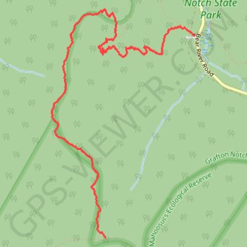
Hike to Old Speck Mountain from the Grafton Notch Parking via the Appalachian Trail and the Grafton Trail in the Grafton Notch State Park and the Mahoosucs Ecological Reserve. #Hiking #Mountain #Nature #Forest #Park
- Distance: 6.1 Km
- Elevation gain: 774 m
- Maximum elevation: 1,222 m
- Elevation loss: 11 m
- Minimum elevation: 458 m
- Moving time: 2 h 17 m
- Moving speed: 2.7 Km/h
- Maximum speed: 16.3 Km/h
- Total time: 3 h 6 m
- Global speed: 2.0 Km/h
Interactive trail map
Trail profile
- Distance: 6.1 Km
- Elevation gain: 774 m
- Maximum elevation: 1,222 m
- Elevation loss: 11 m
- Minimum elevation: 458 m
- Moving time: 2 h 17 m
- Moving speed: 2.7 Km/h
- Maximum speed: 16.3 Km/h
- Total time: 3 h 6 m
- Global speed: 2.0 Km/h
About this trail
Name: Old Speck Mountain trail, distance, elevation, map, profile, GPS track
Start: Appalachian Trail, Grafton Township, Oxford County, Maine, 04261, United States (44.59004 -70.94698)
End: Appalachian Trail, Grafton Township, Oxford County, Maine, 04261, United States (44.57200 -70.95814)
Coordinates: 44.57200 -70.96483 44.59232 -70.94698
Other hiking, mountain biking, running and outdoor activity trails
Click on a trail to view its statistics, map and profile.