Old Speck Mountain
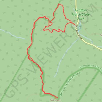
Hike to Old Speck Mountain via Appalachian Trail, Eyebrow Trail and Grafton Loop Trail in the Grafton Notch State Park. #Hiking #Mountain #Forest #Nature #Park
- Distance: 11.1 Km
- Elevation gain: 866 m
- Maximum elevation: 1,266 m
- Elevation loss: 866 m
- Minimum elevation: 459 m
- Moving time: 4 h 8 m
- Moving speed: 2.7 Km/h
- Maximum speed: 5.3 Km/h
- Total time: 4 h 38 m
- Global speed: 2.4 Km/h
Interactive trail map
Trail profile
- Distance: 11.1 Km
- Elevation gain: 866 m
- Maximum elevation: 1,266 m
- Elevation loss: 866 m
- Minimum elevation: 459 m
- Moving time: 4 h 8 m
- Moving speed: 2.7 Km/h
- Maximum speed: 5.3 Km/h
- Total time: 4 h 38 m
- Global speed: 2.4 Km/h
About this trail
Name: Old Speck Mountain trail, distance, elevation, map, profile, GPS track
End: Appalachian Trail, Grafton Township, Oxford County, Maine, 04261, United States (44.59005 -70.94716)
Coordinates: 44.57070 -70.96495 44.59565 -70.94711
Other hiking, mountain biking, running and outdoor activity trails
Click on a trail to view its statistics, map and profile.