Baw Baw National Park
Interactive trail map
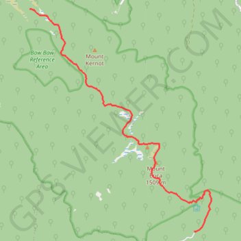
Trail profile
- Distance: 10.5 Km
- Elevation gain: 623 m
- Maximum elevation: 1,499 m
- Elevation loss: 235 m
- Minimum elevation: 1,085 m
About this trail
Name: Baw Baw National Park trail, distance, elevation, map, profile, GPS track
Start: Australian Alps Walking Track, Baw Baw, Shire of Baw Baw, Victoria, Australia (-37.89220 146.35540)
End: Australian Alps Walking Track, Baw Baw, Shire of Baw Baw, Victoria, Australia (-37.84017 146.30646)
Coordinates: -37.89245 146.30646 -37.84017 146.36039
Other hiking, mountain biking, running and outdoor activity trails
Click on a trail to view its statistics, map and profile.
Traralgon - Walhalla - Woods Point
Australia > Victoria > Traralgon
#Bike
Distance: 124.6 Km • Elevation gain: 4,258 m • Maximum elevation: 1,165 m
Moe - Woods Point
#Bike
Distance: 109.2 Km • Elevation gain: 3,295 m • Maximum elevation: 1,165 m
Snow Gum Run Mount Baw Baw
Australia > Victoria > Mount Baw Baw Alpine Resort
Distance: 15.1 Km • Elevation gain: 465 m • Maximum elevation: 1,554 m