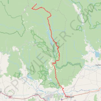
Traralgon - Walhalla - Woods Point
#Bike
- Distance: 124.6 Km
- Elevation gain: 4,258 m
- Maximum elevation: 1,165 m
- Elevation loss: 3,616 m
- Minimum elevation: 29 m
Interactive trail map
Trail profile
- Distance: 124.6 Km
- Elevation gain: 4,258 m
- Maximum elevation: 1,165 m
- Elevation loss: 3,616 m
- Minimum elevation: 29 m
About this trail
Name: Traralgon - Walhalla - Woods Point trail, distance, elevation, map, profile, GPS track
Start: 31, Princes Street, Traralgon, City of Latrobe, Victoria, 3844, Australia (-38.19833 146.53899)
Coordinates: -38.19833 146.21639 -37.57033 146.53899
Other hiking, mountain biking, running and outdoor activity trails
Click on a trail to view its statistics, map and profile.
Moe - Woods Point
#Bike
Distance: 109.2 Km • Elevation gain: 3,295 m • Maximum elevation: 1,165 m
Every trail at Haunted Hills
Distance: 36.4 Km • Elevation gain: 848 m • Maximum elevation: 165 m
Snow Gum Run Mount Baw Baw
Australia > Victoria > Mount Baw Baw Alpine Resort
Distance: 15.1 Km • Elevation gain: 465 m • Maximum elevation: 1,554 m
Bruntons Eaglehawk
Distance: 23.6 Km • Elevation gain: 352 m • Maximum elevation: 413 m