Thank you for supporting this site ❤️
Make a donation
Make a donation
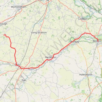
2026-04-17_17-02_Fri
- Distance: 55.6 Km
- Elevation gain: 274 m
- Maximum elevation: 58 m
- Elevation loss: 227 m
- Minimum elevation: 1 m
Interactive trail map
Thank you for supporting this site ❤️
Make a donation
Make a donation
Trail profile
- Distance: 55.6 Km
- Elevation gain: 274 m
- Maximum elevation: 58 m
- Elevation loss: 227 m
- Minimum elevation: 1 m
Thank you for supporting this site ❤️
Make a donation
Make a donation
About this trail
Name: 2026-04-17_17-02_Fri trail, distance, elevation, map, profile, GPS track
Coordinates: 52.36133 1.03477 52.48569 1.57064
Thank you for supporting this site ❤️
Make a donation
Make a donation
Other hiking, mountain biking, running and outdoor activity trails
Click on a trail to view its statistics, map and profile.
Loop walk from Kenninghall
United Kingdom > England > Norfolk > Breckland District > Kenninghall > Edge Green
Distance: 12.6 Km • Elevation gain: 59 m • Maximum elevation: 56 m
Walk round Old Buckenham
United Kingdom > England > Norfolk > Breckland District > Old Buckenham
Distance: 17.6 Km • Elevation gain: 77 m • Maximum elevation: 53 m