Lost Maples State Natural Reserve East Trail
Afternoon Walk
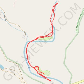
- Distance: 5.1 Km
- Elevation gain: 62 m
- Maximum elevation: 571 m
- Elevation loss: 63 m
- Minimum elevation: 546 m
- Moving time: 1 h 18 m
- Moving speed: 3.9 Km/h
- Maximum speed: 7.1 Km/h
- Total time: 2 h 31 m
- Global speed: 2.0 Km/h
Interactive trail map
Trail profile
- Distance: 5.1 Km
- Elevation gain: 62 m
- Maximum elevation: 571 m
- Elevation loss: 63 m
- Minimum elevation: 546 m
- Moving time: 1 h 18 m
- Moving speed: 3.9 Km/h
- Maximum speed: 7.1 Km/h
- Total time: 2 h 31 m
- Global speed: 2.0 Km/h
About this trail
Name: Lost Maples State Natural Reserve East Trail trail, distance, elevation, map, profile, GPS track
Start: Ranch Road 187, Bandera County, Texas, 78885, United States (29.81015 -99.57350)
End: 37221, Ranch Road 187, Bandera County, Texas, 78885, United States (29.80953 -99.57255)
Coordinates: 29.80819 -99.57614 29.82246 -99.56960
Other hiking, mountain biking, running and outdoor activity trails
Click on a trail to view its statistics, map and profile.