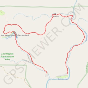
Lost Maples State Natural Area Loop
Loop hike in Lost Maples State Natural Area via East Trail, The Grotto, Birds Eye View, Can Creek and Lost Maples State Dam. #Hiking #Loop #Nature #Forest #Mountain #Overlook #River #Park
- Distance: 6.6 Km
- Elevation gain: 193 m
- Maximum elevation: 687 m
- Elevation loss: 197 m
- Minimum elevation: 557 m
- Moving time: 2 h 57 m
- Moving speed: 2.2 Km/h
- Maximum speed: 5.1 Km/h
- Total time: 3 h 18 m
- Global speed: 2.0 Km/h
Interactive trail map
Trail profile
- Distance: 6.6 Km
- Elevation gain: 193 m
- Maximum elevation: 687 m
- Elevation loss: 197 m
- Minimum elevation: 557 m
- Moving time: 2 h 57 m
- Moving speed: 2.2 Km/h
- Maximum speed: 5.1 Km/h
- Total time: 3 h 18 m
- Global speed: 2.0 Km/h
About this trail
Name: Lost Maples State Natural Area Loop trail, distance, elevation, map, profile, GPS track
Start: East Trail, Bandera County, Texas, 78885, United States (29.81661 -99.57085)
End: East Trail, Bandera County, Texas, 78885, United States (29.81679 -99.57644)
Coordinates: 29.81661 -99.58862 29.83120 -99.56590
Other hiking, mountain biking, running and outdoor activity trails
Click on a trail to view its statistics, map and profile.
Lost Maples State Natural Reserve East Trail
United States > Texas > Bandera County
Afternoon Walk
Distance: 5.1 Km • Elevation gain: 62 m • Maximum elevation: 571 m