Katie, Jack's Ridge, Black House Branch, Station Camp Creek and Duncan Hollow Trails
Big South Fork National River and Recreation Area
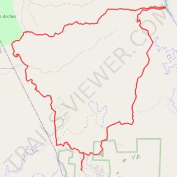
- Distance: 26.0 Km
- Elevation gain: 556 m
- Maximum elevation: 487 m
- Elevation loss: 555 m
- Minimum elevation: 255 m
Interactive trail map
Trail profile
- Distance: 26.0 Km
- Elevation gain: 556 m
- Maximum elevation: 487 m
- Elevation loss: 555 m
- Minimum elevation: 255 m
About this trail
Name: Katie, Jack's Ridge, Black House Branch, Station Camp Creek and Duncan Hollow Trails trail, distance, elevation, map, profile, GPS track
Start: Scott County, East Tennessee, Tennessee, United States (36.48913 -84.70226)
End: Scott County, East Tennessee, Tennessee, United States (36.48920 -84.70212)
Coordinates: 36.48910 -84.73306 36.54664 -84.66579
Other hiking, mountain biking, running and outdoor activity trails
Click on a trail to view its statistics, map and profile.
Big Island Loop - Cumberland River South Fork
United States > Tennessee > Scott County
Scott County Dia
Distance: 18.8 Km • Elevation gain: 403 m • Maximum elevation: 452 m
Big South Fork National River and Recreation Area
United States > Tennessee > Scott County
Scott County Dia
Distance: 29.2 Km • Elevation gain: 668 m • Maximum elevation: 487 m
John Litton Farm Hike Loop
United States > Tennessee > Scott County
Scott State Forest, Fall Branch, Scott County Trail Running
Distance: 7.6 Km • Elevation gain: 159 m • Maximum elevation: 481 m
Cumberland Valley Loop Trail
United States > Tennessee > Fentress County
Fentress County Dia
Distance: 29.3 Km • Elevation gain: 513 m • Maximum elevation: 485 m