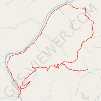
Big Island Loop - Cumberland River South Fork
Scott County Dia
- Distance: 18.8 Km
- Elevation gain: 403 m
- Maximum elevation: 452 m
- Elevation loss: 405 m
- Minimum elevation: 246 m
Interactive trail map
Trail profile
- Distance: 18.8 Km
- Elevation gain: 403 m
- Maximum elevation: 452 m
- Elevation loss: 405 m
- Minimum elevation: 246 m
About this trail
Name: Big Island Loop - Cumberland River South Fork trail, distance, elevation, map, profile, GPS track
Start: Station Camp Road, Scott County, East Tennessee, Tennessee, United States (36.55707 -84.65932)
End: Station Camp Road, Scott County, East Tennessee, Tennessee, United States (36.55705 -84.65948)
Coordinates: 36.54606 -84.67098 36.58029 -84.63124
Other hiking, mountain biking, running and outdoor activity trails
Click on a trail to view its statistics, map and profile.
Katie, Jack's Ridge, Black House Branch, Station Camp Creek and Duncan Hollow Trails
United States > Tennessee > Scott County
Big South Fork National River and Recreation Area
Distance: 26.0 Km • Elevation gain: 556 m • Maximum elevation: 487 m
Big South Fork National River and Recreation Area
United States > Tennessee > Scott County
Scott County Dia
Distance: 29.2 Km • Elevation gain: 668 m • Maximum elevation: 487 m