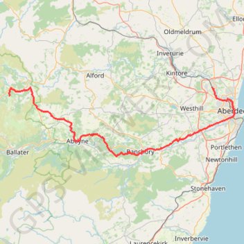
Ride along the River Dee
- Distance: 101.1 Km
- Elevation gain: 1,220 m
- Maximum elevation: 371 m
- Elevation loss: 982 m
- Minimum elevation: 5 m
- Moving time: 8 h 45 m
- Moving speed: 11.6 Km/h
- Maximum speed: 35.7 Km/h
- Total time: 11 h 21 m
- Global speed: 8.9 Km/h
Interactive trail map
Trail profile
- Distance: 101.1 Km
- Elevation gain: 1,220 m
- Maximum elevation: 371 m
- Elevation loss: 982 m
- Minimum elevation: 5 m
- Moving time: 8 h 45 m
- Moving speed: 11.6 Km/h
- Maximum speed: 35.7 Km/h
- Total time: 11 h 21 m
- Global speed: 8.9 Km/h
About this trail
Name: Ride along the River Dee trail, distance, elevation, map, profile, GPS track
Coordinates: 57.03909 -3.07754 57.20369 -2.09164
Other hiking, mountain biking, running and outdoor activity trails
Click on a trail to view its statistics, map and profile.
Ballater
United Kingdom > Scotland > Aberdeenshire > Ballater
Mountain Bike Ride #UK #Aberdeenshire #Ballater
Distance: 9.5 Km • Elevation gain: 43 m • Maximum elevation: 204 m
Aberdeen Beach
United Kingdom > Scotland > Aberdeen City
Distance: 1.8 Km • Elevation gain: 8 m • Maximum elevation: 14 m