Aberdeen Beach
- Distance: 1.8 Km
- Elevation gain: 8 m
- Maximum elevation: 14 m
- Elevation loss: 17 m
- Minimum elevation: 1 m
- Moving time: 34 m 1 s
- Moving speed: 3.2 Km/h
- Maximum speed: 6.8 Km/h
- Total time: 44 m 59 s
- Global speed: 2.4 Km/h
Interactive trail map
Trail profile
- Distance: 1.8 Km
- Elevation gain: 8 m
- Maximum elevation: 14 m
- Elevation loss: 17 m
- Minimum elevation: 1 m
- Moving time: 34 m 1 s
- Moving speed: 3.2 Km/h
- Maximum speed: 6.8 Km/h
- Total time: 44 m 59 s
- Global speed: 2.4 Km/h
About this trail
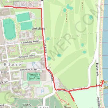
Name: Aberdeen Beach trail, distance, elevation, map, profile, GPS track
Coordinates: 57.15735 -2.09289 57.16462 -2.07885
Other hiking, mountain biking, running and outdoor activity trails
Click on a trail to view its statistics, map and profile.
Ride along the River Dee
United Kingdom > Scotland > Aberdeen City
Distance: 101.1 Km • Elevation gain: 1,220 m • Maximum elevation: 371 m