Grays Peak and Torreys Peak via Grays Peak Trail in Arapaho National Forest
The hike to Grays and Torreys Peaks offers an accessible yet challenging adventure through Colorado’s alpine terrain. Beginning in a lush valley at the Stevens Gulch Trailhead, the trail quickly ascends above the tree line, presenting sweeping views of Kelso Mountain and the Continental Divide. Along the well-maintained route, hikers encounter vibrant wildflower meadows, rugged switchbacks, and a shared saddle between the peaks, culminating in breathtaking panoramas from the summits of both Grays and Torreys Peaks, showcasing the rugged beauty of the Rockies. #Hiking #Mountain #Nature
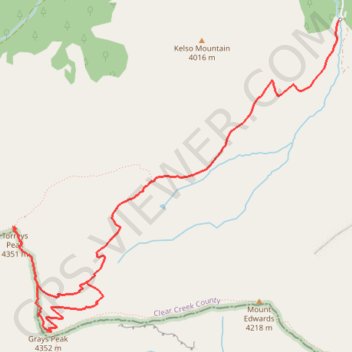
- Distance: 12.8 Km
- Elevation gain: 1,089 m
- Maximum elevation: 4,338 m
- Elevation loss: 1,068 m
- Minimum elevation: 3,431 m
Interactive trail map
Trail profile
- Distance: 12.8 Km
- Elevation gain: 1,089 m
- Maximum elevation: 4,338 m
- Elevation loss: 1,068 m
- Minimum elevation: 3,431 m
About this trail
Name: Grays Peak and Torreys Peak via Grays Peak Trail in Arapaho National Forest trail, distance, elevation, map, profile, GPS track
Start: Grays Peak Trail, Clear Creek County, Colorado, 80476, United States (39.66055 -105.78493)
End: Grays Peak Trail, Clear Creek County, Colorado, 80476, United States (39.65852 -105.78529)
Coordinates: 39.63369 -105.82139 39.66055 -105.78493
Other hiking, mountain biking, running and outdoor activity trails
Click on a trail to view its statistics, map and profile.