Hidden Valley Loop Trail in Joshua Tree National Park
The Hidden Valley Loop Trail in Joshua Tree National Park offers a captivating journey through a landscape adorned with massive, weathered boulders and unique rock formations. As you traverse the loop, you'll encounter a diverse array of desert flora, including Joshua trees, pinyon pines, cacti and various desert shrubs, all thriving in this unique microhabitat. The trail also provides opportunities to observe local wildlife, such as lizards, birds, squirrels, and the occasional bighorn sheep and jackrabbit, all set against the backdrop of the park's distinctive desert scenery. #Hiking #Desert #Rock #Nature #Loop
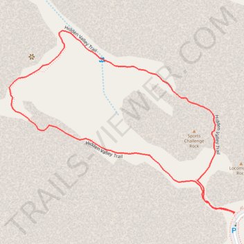
- Distance: 1.6 Km
- Elevation gain: 39 m
- Maximum elevation: 1,302 m
- Elevation loss: 38 m
- Minimum elevation: 1,274 m
- Moving time: 28 m 23 s
- Moving speed: 3.4 Km/h
- Maximum speed: 5.1 Km/h
- Total time: 28 m 23 s
- Global speed: 3.4 Km/h
Interactive trail map
Trail profile
- Distance: 1.6 Km
- Elevation gain: 39 m
- Maximum elevation: 1,302 m
- Elevation loss: 38 m
- Minimum elevation: 1,274 m
- Moving time: 28 m 23 s
- Moving speed: 3.4 Km/h
- Maximum speed: 5.1 Km/h
- Total time: 28 m 23 s
- Global speed: 3.4 Km/h
About this trail
Name: Hidden Valley Loop Trail in Joshua Tree National Park trail, distance, elevation, map, profile, GPS track
Start: Hidden Valley Trail, Riverside County, California, United States (34.01239 -116.16808)
End: Hidden Valley Trail, Riverside County, California, United States (34.01242 -116.16806)
Coordinates: 34.01239 -116.17374 34.01621 -116.16806
Other hiking, mountain biking, running and outdoor activity trails
Click on a trail to view its statistics, map and profile.