McAfee Knob via Appalachian Trail
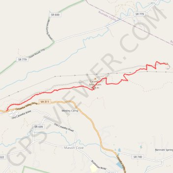
Interactive trail map
Trail profile
- Distance: 12.5 Km
- Elevation gain: 478 m
- Maximum elevation: 952 m
- Elevation loss: 478 m
- Minimum elevation: 594 m
About this trail
Name: McAfee Knob via Appalachian Trail trail, distance, elevation, map, profile, GPS track
Coordinates: 37.38038 -80.08925 37.39325 -80.03703
Other hiking, mountain biking, running and outdoor activity trails
Click on a trail to view its statistics, map and profile.
McAfee Knob via Appalachian Trail on Catawba Mountain
United States > Virginia > Roanoke County > Mason Cove > Medley Camp
The McAfee Knob hike is a must-do for anyone who enjoys panoramic mountain views. The trail offers a mix of shady forest paths, steady inclines, and a few rest stops along the way, making it a comfortable yet challenging route up Catawba Mountain. Once you reach the iconic rock ledge, you’re rewarded with…
Distance: 13.8 Km • Elevation gain: 521 m • Maximum elevation: 952 m