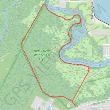
Black Bear Wilderness Loop
Loop hike in the Black Bear Wilderness Area via Black Bear Wilderness Preserve Trail and Saint Johns River. #Hiking #Loop #Nature #Forest #River #Wilderness
- Distance: 11.4 Km
- Elevation gain: 19 m
- Maximum elevation: 7 m
- Elevation loss: 19 m
- Minimum elevation: 2 m
- Moving time: 4 h 46 m
- Moving speed: 2.4 Km/h
- Maximum speed: 4.7 Km/h
- Total time: 4 h 57 m
- Global speed: 2.3 Km/h
Interactive trail map
Trail profile
- Distance: 11.4 Km
- Elevation gain: 19 m
- Maximum elevation: 7 m
- Elevation loss: 19 m
- Minimum elevation: 2 m
- Moving time: 4 h 46 m
- Moving speed: 2.4 Km/h
- Maximum speed: 4.7 Km/h
- Total time: 4 h 57 m
- Global speed: 2.3 Km/h
About this trail
Name: Black Bear Wilderness Loop trail, distance, elevation, map, profile, GPS track
End: Black Bear Wilderness Preserve Trail, Seminole County, Florida, United States (28.83314 -81.35423)
Coordinates: 28.83303 -81.37440 28.86606 -81.34910
Other hiking, mountain biking, running and outdoor activity trails
Click on a trail to view its statistics, map and profile.
Black Bear Wilderness Area Loop Trail
United States > Florida > Seminole County
The Black Bear Wilderness Area Loop Trail offers a rich blend of diverse ecosystems and abundant wildlife, making it a memorable outdoor experience. The trail winds through lush forests, marshes, and along the serene St. Johns River, with highlights including boardwalks that offer close-up views of these…
Distance: 11.9 Km • Elevation gain: 18 m • Maximum elevation: 8 m