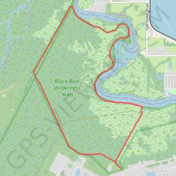
Black Bear Wilderness Area Loop Trail
The Black Bear Wilderness Area Loop Trail offers a rich blend of diverse ecosystems and abundant wildlife, making it a memorable outdoor experience. The trail winds through lush forests, marshes, and along the serene St. Johns River, with highlights including boardwalks that offer close-up views of these environments. Expect to see a variety of wildlife, from birds and alligators to the occasional black bear, making this a perfect spot for nature lovers and photographers alike. The trail is moderately challenging, with minimal elevation gain, making it suitable for most hikers seeking a scenic adventure. #Hiking #Loop #River #Forest #Nature
- Distance: 11.9 Km
- Elevation gain: 18 m
- Maximum elevation: 8 m
- Elevation loss: 18 m
- Minimum elevation: 2 m
- Moving time: 3 h 4 m
- Moving speed: 3.8 Km/h
- Maximum speed: 11.3 Km/h
- Total time: 3 h 29 m
- Global speed: 3.4 Km/h
Interactive trail map
Trail profile
- Distance: 11.9 Km
- Elevation gain: 18 m
- Maximum elevation: 8 m
- Elevation loss: 18 m
- Minimum elevation: 2 m
- Moving time: 3 h 4 m
- Moving speed: 3.8 Km/h
- Maximum speed: 11.3 Km/h
- Total time: 3 h 29 m
- Global speed: 3.4 Km/h
About this trail
Name: Black Bear Wilderness Area Loop Trail trail, distance, elevation, map, profile, GPS track
Start: Black Bear Wilderness Preserve Trail, Seminole County, Florida, United States (28.83306 -81.35401)
Coordinates: 28.83295 -81.37445 28.86612 -81.34907
Other hiking, mountain biking, running and outdoor activity trails
Click on a trail to view its statistics, map and profile.