Etiwanda Falls Trail in San Bernardino National Forest
The Etiwanda Falls Trail, situated in the San Bernardino National Forest near Rancho Cucamonga, California, offers hikers a moderately challenging journey through diverse terrains. The path meanders through chaparral-covered foothills, providing occasional vistas of the surrounding mountains. Upon reaching the falls, visitors are greeted by a serene, tree-lined stream, culminating in a multi-tiered waterfall. #Hiking #Mountain #Forest #Nature #Waterfall
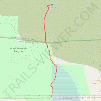
- Distance: 5.2 Km
- Elevation gain: 240 m
- Maximum elevation: 868 m
- Elevation loss: 240 m
- Minimum elevation: 631 m
- Moving time: 44 m 33 s
- Moving speed: 7.0 Km/h
- Maximum speed: 17.5 Km/h
- Total time: 51 m 28 s
- Global speed: 6.1 Km/h
Interactive trail map
Trail profile
- Distance: 5.2 Km
- Elevation gain: 240 m
- Maximum elevation: 868 m
- Elevation loss: 240 m
- Minimum elevation: 631 m
- Moving time: 44 m 33 s
- Moving speed: 7.0 Km/h
- Maximum speed: 17.5 Km/h
- Total time: 51 m 28 s
- Global speed: 6.1 Km/h
About this trail
Name: Etiwanda Falls Trail in San Bernardino National Forest trail, distance, elevation, map, profile, GPS track
Coordinates: 34.16566 -117.52533 34.18620 -117.52190
Other hiking, mountain biking, running and outdoor activity trails
Click on a trail to view its statistics, map and profile.