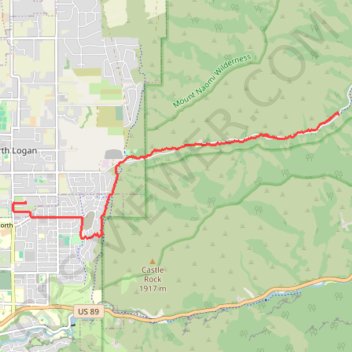
Uinta-Wasatch-Cache National Forest
- Distance: 8.9 Km
- Elevation gain: 63 m
- Maximum elevation: 1,744 m
- Elevation loss: 367 m
- Minimum elevation: 1,422 m
- Moving time: 36 m 41 s
- Moving speed: 14.6 Km/h
- Maximum speed: 44.6 Km/h
- Total time: 49 m 1 s
- Global speed: 10.9 Km/h
Interactive trail map
Trail profile
- Distance: 8.9 Km
- Elevation gain: 63 m
- Maximum elevation: 1,744 m
- Elevation loss: 367 m
- Minimum elevation: 1,422 m
- Moving time: 36 m 41 s
- Moving speed: 14.6 Km/h
- Maximum speed: 44.6 Km/h
- Total time: 49 m 1 s
- Global speed: 10.9 Km/h
About this trail
Name: Uinta-Wasatch-Cache National Forest trail, distance, elevation, map, profile, GPS track
Start: Green Canyon Trail, Cache County, Utah, United States (41.77527 -111.73314)
End: 1300, 1600 North, North Logan, Cache County, Utah, 84341, United States (41.76096 -111.80154)
Coordinates: 41.75493 -111.80432 41.77541 -111.73314
Other hiking, mountain biking, running and outdoor activity trails
Click on a trail to view its statistics, map and profile.
Bonneville Shoreline Trail and Centenial Trail loop
United States > Utah > Cache County > North Logan
Distance: 5.0 Km • Elevation gain: 173 m • Maximum elevation: 1,630 m
Bonneville Shoreline Trail
United States > Utah > Cache County > Logan
cycling, mtb
Distance: 9.3 Km • Elevation gain: 199 m • Maximum elevation: 1,554 m
Green Canyon Trail
United States > Utah > Cache County
Distance: 11.1 Km • Elevation gain: 248 m • Maximum elevation: 2,036 m