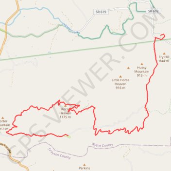
C C Camp Road to Hussy Moutain Horse Campground
- Distance: 22.5 Km
- Elevation gain: 876 m
- Maximum elevation: 1,167 m
- Elevation loss: 687 m
- Minimum elevation: 683 m
Interactive trail map
Trail profile
- Distance: 22.5 Km
- Elevation gain: 876 m
- Maximum elevation: 1,167 m
- Elevation loss: 687 m
- Minimum elevation: 683 m
About this trail
Name: C C Camp Road to Hussy Moutain Horse Campground trail, distance, elevation, map, profile, GPS track
Start: Cripple Creek Road, Shiloh, Wythe County, Virginia, 24322, United States (36.81376 -81.09381)
Coordinates: 36.77129 -81.17448 36.81405 -81.09169
Other hiking, mountain biking, running and outdoor activity trails
Click on a trail to view its statistics, map and profile.
Cripple Creek - Virginia Highlands Horse Trail
United States > Virginia > Wythe County > Shiloh
Distance: 27.3 Km • Elevation gain: 704 m • Maximum elevation: 947 m