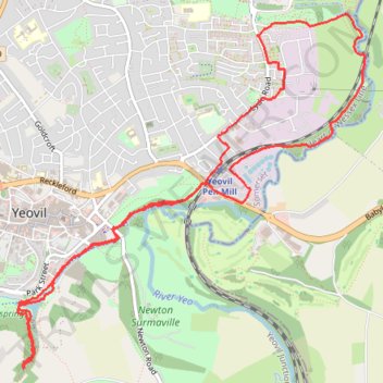
Nine Springs Yeovil Walking Route
- Distance: 9.5 Km
- Elevation gain: 112 m
- Maximum elevation: 66 m
- Elevation loss: 112 m
- Minimum elevation: 25 m
- Moving time: 1 h 57 m
- Moving speed: 4.8 Km/h
- Maximum speed: 54.3 Km/h
- Total time: 2 h 1 m
- Global speed: 4.7 Km/h
Interactive trail map
Trail profile
- Distance: 9.5 Km
- Elevation gain: 112 m
- Maximum elevation: 66 m
- Elevation loss: 112 m
- Minimum elevation: 25 m
- Moving time: 1 h 57 m
- Moving speed: 4.8 Km/h
- Maximum speed: 54.3 Km/h
- Total time: 2 h 1 m
- Global speed: 4.7 Km/h
About this trail
Name: Nine Springs Yeovil Walking Route trail, distance, elevation, map, profile, GPS track
Start: Lyde Road, Yeovil, Somerset, England, BA21 5PL, United Kingdom (50.95255 -2.60876)
End: Lyde Road, Yeovil, Somerset, England, BA21 5PL, United Kingdom (50.95251 -2.60873)
Coordinates: 50.93232 -2.63293 50.95440 -2.59859