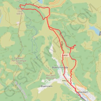
Craig Y Llyn loop
Lunch Walk
- Distance: 17.0 Km
- Elevation gain: 522 m
- Maximum elevation: 603 m
- Elevation loss: 523 m
- Minimum elevation: 182 m
- Moving time: 4 h 33 m
- Moving speed: 3.7 Km/h
- Maximum speed: 10.0 Km/h
- Total time: 5 h 18 m
- Global speed: 3.2 Km/h
Interactive trail map
Trail profile
- Distance: 17.0 Km
- Elevation gain: 522 m
- Maximum elevation: 603 m
- Elevation loss: 523 m
- Minimum elevation: 182 m
- Moving time: 4 h 33 m
- Moving speed: 3.7 Km/h
- Maximum speed: 10.0 Km/h
- Total time: 5 h 18 m
- Global speed: 3.2 Km/h
About this trail
Name: Craig Y Llyn loop trail, distance, elevation, map, profile, GPS track
Start: Station Terrace, Treherbert, Rhondda Cynon Taf, Wales, CF42 5HU, United Kingdom (51.67194 -3.53583)
End: Station Terrace, Treherbert, Rhondda Cynon Taf, Wales, CF42 5HU, United Kingdom (51.67188 -3.53559)
Coordinates: 51.67188 -3.58371 51.71751 -3.53559
Other hiking, mountain biking, running and outdoor activity trails
Click on a trail to view its statistics, map and profile.
The Headstock 500
United Kingdom > Wales > Newport > Newport
Distance: 483.5 Km • Elevation gain: 9,616 m • Maximum elevation: 691 m
Treorchy, Cearphilly, Pen y Fan
United Kingdom > Wales > Caerphilly County Borough > Tredegar
Distance: 127.3 Km • Elevation gain: 1,934 m • Maximum elevation: 501 m