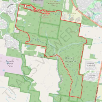
Bayview Conservation Area Loop
- Distance: 21.2 Km
- Elevation gain: 295 m
- Maximum elevation: 75 m
- Elevation loss: 296 m
- Minimum elevation: 8 m
- Moving time: 2 h 27 m
- Moving speed: 8.6 Km/h
- Maximum speed: 16.0 Km/h
- Total time: 2 h 27 m
- Global speed: 8.6 Km/h
Interactive trail map
Trail profile
- Distance: 21.2 Km
- Elevation gain: 295 m
- Maximum elevation: 75 m
- Elevation loss: 296 m
- Minimum elevation: 8 m
- Moving time: 2 h 27 m
- Moving speed: 8.6 Km/h
- Maximum speed: 16.0 Km/h
- Total time: 2 h 27 m
- Global speed: 8.6 Km/h
About this trail
Name: Bayview Conservation Area Loop trail, distance, elevation, map, profile, GPS track
Start: Wolf Peach, Redland Bay, Greater Brisbane, Queensland, 4165, Australia (-27.63463 153.26556)
End: Wolf Peach, Redland Bay, Greater Brisbane, Queensland, 4165, Australia (-27.63441 153.26561)
Coordinates: -27.67553 153.25977 -27.63383 153.29543
Other hiking, mountain biking, running and outdoor activity trails
Click on a trail to view its statistics, map and profile.