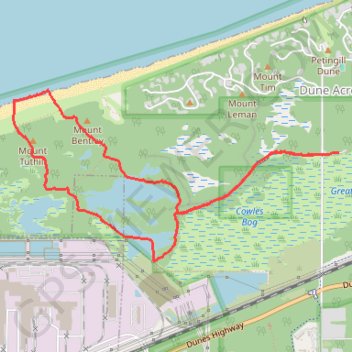
Cowles Bog Trail and Greenbelt Trail Loop around Little Lake in Indiana Dunes National Park
The Cowles Bog Trail and Greenbelt Trail Loopoffers a serene escape into a rich tapestry of diverse ecosystems, including black oak savannas, marshes, and ponds. Hikers can appreciate unique plant species, such as the carnivorous pitcher plants and striking wildflowers, while keeping an eye out for various bird species like sandhill cranes and the elusive Virginia rail. The trail's close proximity to both natural beauty and industrial landscapes creates a fascinating contrast, enhancing the overall experience. #Hiking #Loop #Lake #Beach #Forest #Nature
- Distance: 7.2 Km
- Elevation gain: 63 m
- Maximum elevation: 208 m
- Elevation loss: 63 m
- Minimum elevation: 175 m
- Moving time: 1 h 40 m
- Moving speed: 4.3 Km/h
- Maximum speed: 7.0 Km/h
- Total time: 1 h 44 m
- Global speed: 4.1 Km/h
Interactive trail map
Trail profile
- Distance: 7.2 Km
- Elevation gain: 63 m
- Maximum elevation: 208 m
- Elevation loss: 63 m
- Minimum elevation: 175 m
- Moving time: 1 h 40 m
- Moving speed: 4.3 Km/h
- Maximum speed: 7.0 Km/h
- Total time: 1 h 44 m
- Global speed: 4.1 Km/h
About this trail
Name: Cowles Bog Trail and Greenbelt Trail Loop around Little Lake in Indiana Dunes National Park trail, distance, elevation, map, profile, GPS track
Coordinates: 41.63750 -87.11558 41.64942 -87.08510