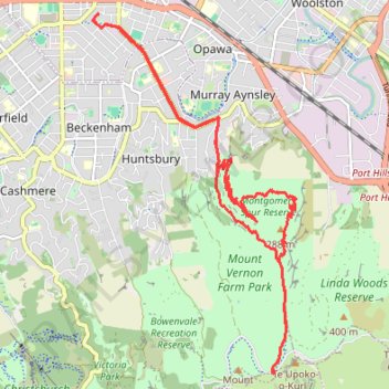
Afternoon Mountain Bike Ride
- Distance: 18.0 Km
- Elevation gain: 451 m
- Maximum elevation: 332 m
- Elevation loss: 451 m
- Minimum elevation: 6 m
- Moving time: 1 h 30 m
- Moving speed: 12.0 Km/h
- Maximum speed: 66.7 Km/h
- Total time: 1 h 43 m
- Global speed: 10.4 Km/h
Interactive trail map
Trail profile
- Distance: 18.0 Km
- Elevation gain: 451 m
- Maximum elevation: 332 m
- Elevation loss: 451 m
- Minimum elevation: 6 m
- Moving time: 1 h 30 m
- Moving speed: 12.0 Km/h
- Maximum speed: 66.7 Km/h
- Total time: 1 h 43 m
- Global speed: 10.4 Km/h
About this trail
Name: Afternoon Mountain Bike Ride trail, distance, elevation, map, profile, GPS track
Coordinates: -43.59480 172.64230 -43.54941 172.67767
Other hiking, mountain biking, running and outdoor activity trails
Click on a trail to view its statistics, map and profile.
Rapaki Track via MTB Singletrack
New Zealand > Canterbury > Christchurch City > Christchurch
Distance: 13.1 Km • Elevation gain: 400 m • Maximum elevation: 332 m
Steadfast reserve - summit
New Zealand > Canterbury > Christchurch City > Banks Peninsula Community > Lyttelton
Distance: 6.7 Km • Elevation gain: 324 m • Maximum elevation: 426 m
Halswell River
New Zealand > Canterbury > Christchurch City > Banks Peninsula Community
Distance: 68.9 Km • Elevation gain: 320 m • Maximum elevation: 40 m