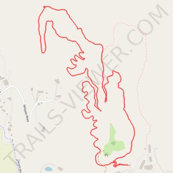
Orange Loop Trail
- Distance: 4.9 Km
- Elevation gain: 121 m
- Maximum elevation: 277 m
- Elevation loss: 121 m
- Minimum elevation: 191 m
- Moving time: 1 h 3 m
- Moving speed: 4.6 Km/h
- Maximum speed: 7.3 Km/h
- Total time: 1 h 5 m
- Global speed: 4.5 Km/h
Interactive trail map
Trail profile
- Distance: 4.9 Km
- Elevation gain: 121 m
- Maximum elevation: 277 m
- Elevation loss: 121 m
- Minimum elevation: 191 m
- Moving time: 1 h 3 m
- Moving speed: 4.6 Km/h
- Maximum speed: 7.3 Km/h
- Total time: 1 h 5 m
- Global speed: 4.5 Km/h
About this trail
Name: Orange Loop Trail trail, distance, elevation, map, profile, GPS track
Coordinates: 39.45751 -81.45741 39.46613 -81.45070
Other hiking, mountain biking, running and outdoor activity trails
Click on a trail to view its statistics, map and profile.
Devola Multi-Use Trail from end to Broughton trailhead
United States > Ohio > Washington County > Devola > Unionville
Distance: 1.7 Km • Elevation gain: 15 m • Maximum elevation: 193 m