Mount MacDonald Loop Hike from Humpback Dam
- Distance: 7.1 Km
- Elevation gain: 349 m
- Maximum elevation: 417 m
- Elevation loss: 349 m
- Minimum elevation: 117 m
- Moving time: 3 h 5 m
- Moving speed: 2.3 Km/h
- Maximum speed: 5.5 Km/h
- Total time: 5 h 11 m
- Global speed: 1.4 Km/h
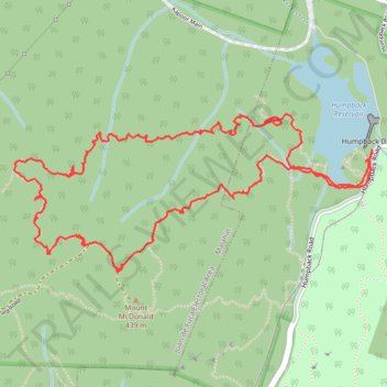
Interactive trail map
Trail profile
- Distance: 7.1 Km
- Elevation gain: 349 m
- Maximum elevation: 417 m
- Elevation loss: 349 m
- Minimum elevation: 117 m
- Moving time: 3 h 5 m
- Moving speed: 2.3 Km/h
- Maximum speed: 5.5 Km/h
- Total time: 5 h 11 m
- Global speed: 1.4 Km/h
About this trail
Name: Mount MacDonald Loop Hike from Humpback Dam trail, distance, elevation, map, profile, GPS track
Coordinates: 48.44291 -123.57576 48.44905 -123.55484
Other hiking, mountain biking, running and outdoor activity trails
Click on a trail to view its statistics, map and profile.
Waugh Creek Falls from Humpback Reservoir
Canada > British Columbia > Capital Regional District > Langford
Sooke Hills Wilderness Regional Park. #Hiking #MTB #WaughCreek #Humpback #SookeHills
Distance: 5.6 Km • Elevation gain: 190 m • Maximum elevation: 165 m
Mount Wells from Humpback Dam
Canada > British Columbia > Capital Regional District > Langford
Mount Wells Regional Park. Vancouver Island. #Hiking #MountWells #Vancouver
Distance: 2.7 Km • Elevation gain: 219 m • Maximum elevation: 337 m